Back مقاطعة سيسيل (ماريلاند) Arabic سسیل بؤلگهسی، مریلند AZB Cecil County, Maryland BAR Сисъл (окръг, Мериленд) Bulgarian সেসিল কাউন্টি, মেরিল্যান্ড BPY Cecil Gông (Maryland) CDO Сесил (гуо, Мэриленд) CE Cecil County CEB Cecil County, Maryland Welsh Cecil County German
Cecil County | |
|---|---|
 | |
|
| |
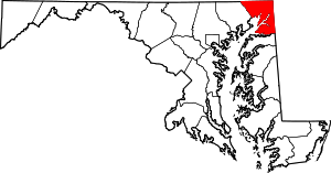
 Location within the U.S. state of Maryland | |
 Maryland's location within the U.S. | |
| Coordinates: 39°34′N 75°57′W / 39.57°N 75.95°W | |
| Country | |
| State | |
| Founded | June 6, 1674 |
| Named for | Cecil Calvert |
| Seat | Elkton |
| Largest town | Elkton |
| Area | |
| • Total | 418 sq mi (1,080 km2) |
| • Land | 346 sq mi (900 km2) |
| • Water | 72 sq mi (190 km2) 17% |
| Population (2020) | |
| • Total | 103,725 |
| • Density | 250/sq mi (96/km2) |
| Time zone | UTC−5 (Eastern) |
| • Summer (DST) | UTC−4 (EDT) |
| Congressional district | 1st |
| Website | www |
Cecil County (SEE-sil) is a county located in the U.S. state of Maryland at the northeastern corner of the state, bordering both Pennsylvania and Delaware. As of the 2020 census, the population was 103,725.[1] The county seat is Elkton.[2] The county is part of the Mid-Eastern Shore region of the state.
The county was named for Cecil Calvert, 2nd Baron Baltimore (1605–1675), the first Proprietary Governor of the Province (colony) of Maryland. With the eastern part of the county closer to Philadelphia than Baltimore, it is part of the Philadelphia–Camden–Wilmington, PA–NJ–DE–MD Metropolitan Statistical Area.[3] The county is located in Wilmington's Radio Market and Baltimore's Designated Market Area.
- ^ "State & County QuickFacts". United States Census Bureau. Retrieved November 25, 2021.
- ^ "Find a County". National Association of Counties. Archived from the original on May 31, 2011. Retrieved June 7, 2011.
- ^ Office of Management and Budget. "OMB BULLETIN NO. 13-01" (PDF). Office of Management and Budget – via National Archives.

